The Magnitude Scale That Measures The World’s Fury: Decoding Earthquake Intensity
The Magnitude Scale That Measures The World’s Fury: Decoding Earthquake Intensity
Earthquakes are among nature’s most powerful and unpredictable forces, capable of reshaping landscapes and communities within seconds. At the core of understanding their potential devastation lies the Magnitude Scale of an Earthquake — a precise system that quantifies seismic energy release and helps scientists, policymakers, and emergency managers assess risk. From minor tremors to catastrophic events, magnitude scales transform chaotic ground shaking into measurable data, enabling earlier warnings, improved preparedness, and safer responses.
This article unpacks the evolution, mechanics, and real-world impact of earthquake magnitude scales, revealing how a single number captures the raw power of a quake.
The Birth of Measurement: From Destruction to Data
Before the 20th century, earthquake impacts were assessed only through subjective damage reports, eyewitness accounts, and damage inventories—methods prone to inconsistency. The game changed with the development of seismology, most notably with the introduction of the Richter Scale in the 1930s.Developed by Charles F. Richter at the California Institute of Technology, this logarithmic scale measured the amplitude of seismic waves recorded by seismographs, offering the first systematic way to compare earthquake strength. Richter’s scale, though revolutionary, primarily served local regions and struggled with very large or distant quakes.
Its limitations spurred global innovation, leading to the development of more robust, comprehensive systems. Today, modern magnitude scales integrate diverse seismic data to provide accurate, standardized readings across all earthquake types and locations. These scales no longer just quantify force — they translate into actionable intelligence for communities, governments, and emergency services.
Understanding Magnitude Scales: Types and Technical Nuances
Modern seismology uses several magnitude scales, each suited to specific contexts.While the Richter Scale remains iconic, today’s primary metrics include the Moment Magnitude Scale (Mw), the Surface Wave Magnitude (Ms), and the Body Wave Magnitude (Mb), each measuring different seismic wave types and energy distributions. The Moment Magnitude Scale, introduced in the 1970s, is now the standard for large earthquakes. Unlike earlier methods, Mw accurately captures total energy release by accounting for fault rupture area, slip displacement, and rock rigidity—offering a more comprehensive picture of seismic potential.
The Surface Wave Magnitude emphasizes seismic waves traveling along Earth’s surface, making it effective for regional assessments, especially for moderate quakes in sedimentary basins. Meanwhile, the Body Wave Magnitude focuses on high-frequency waves generated by a quake’s initial, fastest-traveling seismic pulses, helping pinpoint epicenter location and initial impact. These scales serve distinct purposes: Mw dominates global reporting, Ms is used historically and in certain regions, and Mb aids rapid response for near-tremor shaking.
Despite differences, all magnitude scales converge on a single truth—seismic energy measured in numerical precision.
What Exactly Does an Earthquake Magnitude Represent?
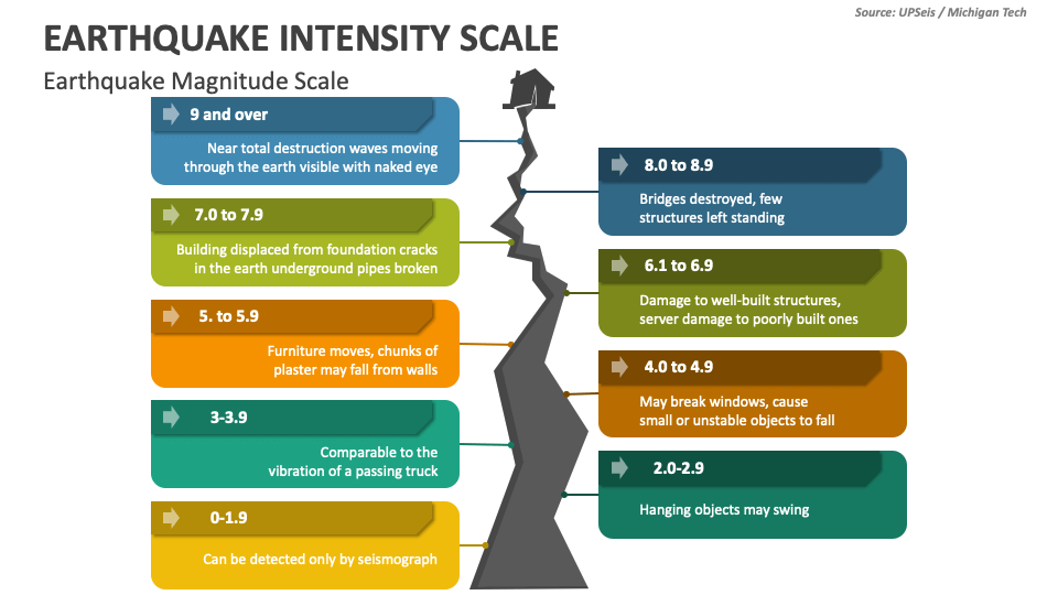
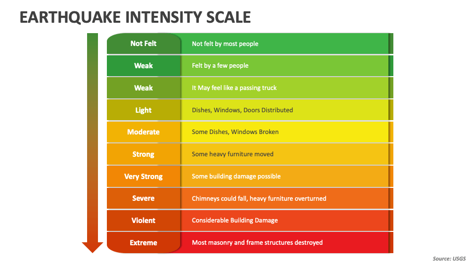
Magnitude is not a measure of shaking intensity, which is assessed separately through the modified Mercalli Intensity Scale. Instead, magnitude quantifies the total energy released at an earthquake’s source beneath the ground.This energy travels as seismic waves, decaying with distance but releasing power measured in joules—often converted into a logarithmic scale for clarity. Each unit increase in magnitude represents roughly 31.6 times more energy release. For example, a magnitude 6 quake releases about 30 times more energy than a magnitude 5 event.
This exponential nature explains why even relatively small increases in magnitude can lead to dramatically greater destruction, as seen in the 2010 Haiti magnitude 7 quake versus California’s frequent magnitude 6 quakes. Scientists use magnitude data in real time to: - Activate early warning systems - Estimate ground acceleration and expected shaking - Guide building safety protocols - Inform disaster response coordination Magnitude’s clarity allows rapid assessment without relying on variable surface conditions, making it the foundation of modern seismic monitoring.
Real-World Examples: Magnitude in Action
Examining notable earthquakes reveals how magnitude scales shape risk perception and response.The 2011 Tōhoku earthquake in Japan, registering 9.0–9.1 on the moment magnitude scale, triggered a devastating tsunami that reshaped coastal districts and nuclear safety policies worldwide. Though magnitude indicated immense power, the tsunami—unforeseen in scale by early warnings—worsened damage beyond what magnitude alone predicted. In contrast, the 1989 Loma Prieta quake in California measured 6.9 magnitude, causing 63 deaths and $6 billion in damage.
Its moderate magnitude contrasted with extreme urban impact due to shallow depth and proximity to populated areas—highlighting that vulnerability complements magnitude in determining real-world consequences. Even smaller quakes, like the 2016 magnitude 5.8 Central Italy event, underscore the role of magnitude in triggering emergency protocols despite limited shaking intensity, emphasizing the scale’s importance in preparedness.
The Human Dimension: How Magnitude Shapes Response
While magnitude remains a scientific metric, its implications ripple through emergency management and public safety.High-magnitude quakes demand immediate, large-scale mobilization—deploying search teams, deploying field hospitals, and activating national crisis plans. In Japan, the magnitude 9+ Tōhoku quake spurred advances in seismic-resistant infrastructure and tsunami nuclear safeguards. Lower-magnitude events often trigger community drills, public warnings, and infrastructure checks rather than nationwide mobilization.
Yet even a magnitude 4 quake can prompt evacuations in earthquake-prone zones, where preparedness hinges on accurate risk interpretation. Municipal planners and insurers use magnitude data to: - Enforce building codes tuned to regional risk - Model potential damage scenarios - Allocate resources efficiently The magnitude scale thus bridges scientific measurement and human safety, transforming abstract numbers into life-saving action.
The Future of Magnitude: Precision, Integration, and Global Collaboration
As seismic networks grow denser and satellite technology advances, the Magnitude Scale evolves toward real-time, high-resolution data fusion.Researchers now combine seismic, GPS, and satellite InSAR (Interferometric Synthetic Aperture Radar) measurements to refine magnitude estimates within minutes—critical for early warnings that save seconds that may mean lives. International cooperation ensures consistent magnitude reporting across borders, reinforcing public trust and coordinated response. Projects like the Global Seismographic Network (GSN) and the Integrated Global Seismographic Network (IGSN) standardize data collection, making magnitude scales more reliable than ever.
For communities worldwide, the Magnitude Scale stands as a silent guardian—quantifying the unseen, translating ground motion into shared understanding. In a world where earthquakes strike without warning, this standardized measure remains humanity’s clearest lens into seismic power, enabling smarter, safer, and more resilient responses. The scale does more than label destruction—it empowers prevention.


Related Post
Unveiling Kash Patel's Private World: Better Half and Progeny

Delta CRJ900 A Deep Dive: Power, Performance, and Precision in the Jet Age
Bruce Beck NBC Bio Wiki Age Height Wife Camp Salary and Net Worth


